
To the best of our knowledge Walterstone Castle, at the south end of Ewyas Lacy, is not named as such in any historical document. It is reasonably inferred that the name Walterstone derives from Walter’s town, a new settlement established by Walter de Lacy when he began expanding out from Norman-held Ewyas Harold into Welsh territory, not long after 1066. Walterstone would have had an important role in observing and deterring, or at least delaying, the approach of a force from Brycheiniog or Gwent intent on raiding into the Golden Valley. Only 5 miles from Ewyas Harold and 3 miles from Longtown, if it were attacked it could be readily reinforced.
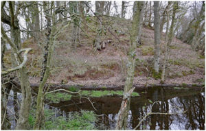
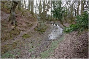
Walterstone Castle has an impressively tall motte surrounded by a wide and deep water-filled ditch, with a crescent shaped bailey to the east. Although it is not on a particularly elevated position, the views are spectacular and the castle commands the entrance to the Monnow valley from the south and west. Three Iron Age forts are clearly visible from the castle – those of Walterstone, the Skirrid and Pentwyn.
There is a lot of loose rubble on the top and sides of the motte but none of this appears to be part of any built structure and it may simply be the motte material quarried from the ditch. It has been reported that the top of the motte has a rim in places, which could be the foundations of a shell keep or a stockade. During our visits we were unable to locate any rim and what’s more, with a diameter of only 12 or 13 metres, similar to that at nearby Ponthendre, the summit seems to be too small for a shell keep. It is likely that the motte would have been lowered before building any stone tower to increase the summit area, as can be seen at Longtown. If there ever was a stone tower or shell keep, then it has been very thoroughly robbed out, leaving no sign of either foundations or robbing trenches. Our feeling is that Walterstone probably only ever had a wooden tower, until it was finally abandoned, some time after 1189, when Longtown’s wooden tower had already been replaced with a stone keep*.
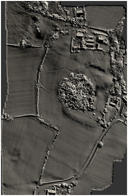
The terrain model shows the crescent-shaped bailey wrapped around the east side of the motte and extending to the road. Remfrey perceived three small separate baileys but these would have been an unusual and impractical arrangement. Sometimes the fields around the motte can be waterlogged, so it is more likely that the bailey has simply been divided by two later drainage ditches.
On the slightly higher ground to the north of the motte, there is the suggestion of a second bailey, its boundary obscured by the farm buildings. A second bailey is only to be expected given the importance of Walterstone before its eclipse by Longtown. Ridge and furrow fields can be seen to the west and south.
Walterstone Castle is on private land but the tree-covered motte can be seen from the footpath running along the west side.
- Shoesmith says Walterstone was abandoned by 1137 but the source for this date is unknown to other researchers.