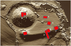
The following is a short summary of the excavation results from two 3-week seasons of excavation at Longtown Castle Green and Ponthendre.
Further details can be found in Herefordshire Archaeology’s Interim and Final Reports, HAR364 and HAR375.
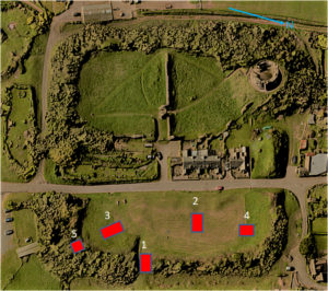
The plans based on digital terrain models show trench numbers and positions. Numbers in brackets identify contexts. Round brackets (xxx) are deposits. Square brackets [xxx] are cuts.
Radiocarbon (C14) date ranges are calibrated with a 95.4% probability, unless otherwise stated.
Longtown Castle Green
Castle Green Trench 1
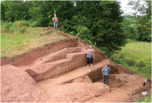 The earliest plan of the Green (see Castle Images) shows a gate on the east side of the rampart, indicating that a field entrance already existed here in 1718. Trench 1 used the side of this gap to produce a stepped section through the rampart. The section showed that the rampart had been built in three phases.
Roman
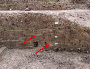 The first phase, currently standing 0.55m high, was built with blocks of turf. Fragments of charcoal from the lowest level gave a wide C14 date range from 355 to 117BC. This might suggest that this part of the rampart was begun in the Iron Age, but the regular square shape of the rampart as a whole is more suggestive of a Roman fort. In which case, either the charcoal lay in the turf for a long period before the turf was used or more probably it derived from a mature tree. C14 dating gives the date when wood was growing not when it was cut, so charcoal from a 300 year old oak tree can give a date 300 years earlier than its burning date.
Medieval
The second phase raised the rampart to a height of around four metres and was made up of layers of earth, subsoil and degraded sandstone and mudstone, mostly if not all derived from digging the ditch around the rampart. There was no sign of any timber or stone revetment and nothing that gave any indication of a date. Arguably the absence of any dating evidence may support the view that Harold Godwinson’s army of Anglo-Saxons was responsible for this phase. Anglo-Saxon pottery is relatively rare outside of urban areas and is very poorly preserved.
The second phase was present for long enough to acquire a covering of turf before being covered by the third phase, which added another 0.3m of soil to the top of the rampart. This contained a few sherds of 13th to 15th century pottery, but these may not be concurrent with the third phase because of the amount of disturbance from tree roots and animal burrows.
A small area of the top of the rampart was sampled to look for remains of a wall or stockade but there was no evidence that the rampart had any additional defences.
Post-medieval
A 3m deep drain running from the Green out to the field entrance contained some Victorian pottery. Its depth suggests that it may have been the drain for a saw-pit known to have been located somewhere on the Green in the 1890s.
Castle Green Trench 2
This trench was excavated over two seasons and provided the best evidence for activities taking place on the Green.
Roman
Two sondages or small trial pits in Trench 2 exposed interesting Roman features.
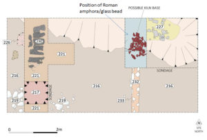 The deepest (and oldest) section of Trench 2 was a 1 metre thick deposit of silt and gravel (217) that contained 11 fragments of Roman pottery. These were probably of the type known as Severn Valley Ware and included part of a ring-necked flagon. Severn Valley Ware is found at Roman forts from the first century and has a wider distribution in later centuries. A radiocarbon date from this context gave a range of 53 – 131AD.
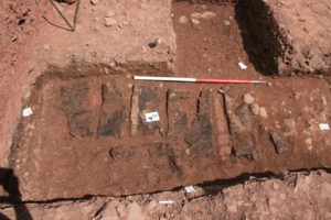 A metalled surface (221) had been laid down over this deposit. Six or seven short wooden planks had been placed on the metalled surface and above these was a thick layer of burnt clay and charcoal (220), the remains of a kiln or oven. The heat from this had completely carbonised the planks below, but they were still recognisable as oak. The planks were probably either part of a duckboard or the base for the kiln/oven. Charcoal from this level gave a 2nd century BC radiocarbon date range but since it was above layer 217 with its 1st century date it appears that the kiln/oven was being fuelled by wood from old trees.
The broken stone base of a second Roman kiln or oven was found in the other sondage. A horizontal flue from this [232] extended the full width of the trench. A ditch [239] had been cut across the kiln/oven, which contained charcoal, Roman pottery and a blue glass bead. The charcoal gave a C14 date range of 51 – 86AD to 57% probability, while the pottery included a large sherd of amphora, identified as Dressel type 20, used from the 1st to 3rd centuries to ship olive oil from southern Spain.
Medieval
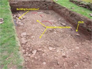 The most obvious feature of Trench 2 was a medieval road running east-west. The surface (216) was cambered and metalled with small stones and gravel. The road was bounded on the south side by a line of stones that may have supported the sill beam of a timber building, and on the north side by a ditch [229] that followed the line of the Roman ditch beneath. The ditch fill included mid 13th century pottery, a considerable quantity of charcoal and a complete horseshoe. Immediately below the road surface, a layer of gravel and clay contained pieces of cooking pot, burnt bone and daub from a demolished building.
Post-medieval
The upper layers of soil contained some small change, slate pencils from the school, pieces of clay tobacco pipe stems and pottery from the 15th to the 19th centuries. There were also two very corroded arrowheads, one leaf shaped the other with a diamond section. These seemed too lightweight to be for military use and may have been from post-medieval sporting arrows.
Castle Green Trench 3
Over the centuries Castle Green had repeatedly been used as a place to dump unwanted debris. Unfortunately Trench 3, in the south-east corner of the Green, was located on what became clear was the largest heap of dumped material. It was extremely difficult to excavate and failed to reach the probably more informative, earlier deposits beneath.
The deepest feature recorded, from around 2m below the present ground level, was a small section of a pebbled surface likely to be a floor or yard (326). A pit had been dug through this. Charcoal from above the floor is currently being radiocarbon dated.
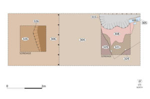
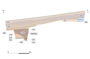
Above this was a massive dump of sandstone rubble and clay, well over a metre deep, (318) and (320), which included no occupational debris. It is probable that this material 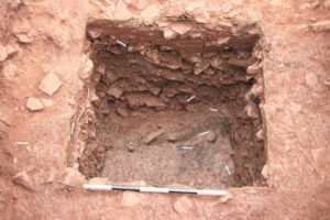 either came from digging a defensive ditch for the new stone walled bailey (in which case it is strange that it was carted away when it could have been used for the rampart) or more likely from lowering the height of the motte to provide a wider platform for the stone keep. Pottery from the layer immediately above, (311), indicated that this first phase of dumping occurred no later than the 12th century.
Later layers of tipped clay and rubble, (306) and (304), added a further metre of height to the dump. These layers contained pottery from the first half of the 13th century. Finds included daub, some still with the impression of wattle, horseshoe nails, smithing slag and a chunk of Wye Valley millstone with a pecked working face. These layers appear to be the remains of demolished buildings cleared from elsewhere, suggesting a major redevelopment of the castle was underway between 1200 and 1250. This may be evidence for clearance of the castle bailey prior to installing the stone dividing wall and inner gateway.
A small building with a clay floor and clay walls appears to have been erected on top of the dump of debris. After this was levelled, another structure with a stone wall was dug into the remains. Pottery sherds suggest that these structures were in use during the mid 13th century.
Castle Green Trench 4
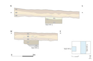
This trench was positioned at the northernmost part of the Green to sample features and activities against the rampart.
Roman
There were no Roman features in Trench 4, only a few pieces of Roman pottery mixed in with later medieval deposits. One of these pieces was a sherd of Samian ware, dated to the 1st century and manufactured at La Graufesenque in southern Gaul.
Medieval
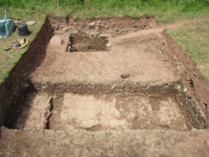
Trench 4 looking north showing the bedrock
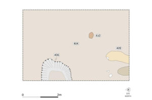
This area appeared to have been cleared of all earlier deposits, down to the bedrock, before being covered with a thick layer of red clay (413). A depression in the surface was lined with a thin layer of clay with a distinctive eau de nil colour (412). This appeared to be the waterproof lining of a cistern but it extended beyond the excavated area making it impossible to determine its size or shape. Above this was a deposit of loose silty clay (411), containing residual Roman pottery, a solitary white glass gaming piece and a high concentration of charcoal that gave a C14 range of 1036 to 1157AD.
Over this a working surface or floor of hard clay (404) had been laid across the entire area of the trench. A void in this surface was interpreted as a posthole, suggesting a building of some sort, while a burnt area was presumed to be a hearth.
Another working surface (402) was laid over this. It too had an area of burning (403). Small pieces of black cooking pot and burnt bone suggested it was a hearth used for cooking. This surface and the one beneath had been cut through by an oval pit [406], around 2m across. The fill of the pit contained 13th century pottery, burnt bone and what appears to be a stout iron blade.
Post-medieval
The topsoil contained small value coins, slate pencils and broken stone roof tiles, recognised by their peg holes.
Castle Green Trench 5
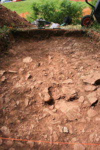
Trench 5 looking north
A trench was opened at the south-east corner of the rampart in a further attempt to determine if it had been topped by any supplementary defences. There were no indications of either a wall or a timber palisade. Either it was deemed that the 5m high rampart with a 5m wide moat was an adequate defence or the rampart had been fortified with a barrier that left no archaeological trace, such as a thorn hedge or an entanglement of cut thorn.
Castle Green Conclusions
The Longtown Castle enclosure does, after all, appear to have begun as a Roman fort, probably built during the Silurian war between 50 and 78AD, as indicated by the pottery and radiocarbon dates. There is no evidence that the ramparts were ever replaced in stone, which suggests that the fort went out of use, probably sometime in the second century AD.
A second phase of rampart building which raised the height to 4m left no evidence as to those responsible, but there is good reason to suspect Harold Godwinson’s army of 1055. A third phase, which raised the height by at least a further 0.3m, is also undated and may have occurred at any time between the Conquest and Owain Glyndwr’s uprising. There was no evidence that the medieval ramparts ever had a timber stockade or revetment. Instead, there may have been a thick thorn hedge.
During the medieval period, Castle Green went through 2 major phases of redevelopment, one in the 12th century, which probably dates to the building of the stone keep and curtain walls, and one in the first half of the 13th century, which probably dates to the building of the stone dividing wall and gateway.
Ponthendre
Ponthendre Trenches 1 and 8
Trench 1 exposed the north-east quarter of the summit of the motte, while Trench 8 was a deeper, metre wide transect from the centre of the motte to the edge. The exposed surface of the motte was made of a purple-red silty clay containing small pieces of green sandstone. Neither trench produced any evidence for a tower or palisade having been built on the motte. Even though a tower built on sill beams might leave no archaeological trace, no occupational debris was found either.
Ponthendre Trenches 2 and 6
 Trench 2 extended 20m over the southern edge of the bailey and down its scarp. It revealed that the bailey was protected by a wet ditch, and the material from the ditch had been used to build a low rampart. The scarp above the ditch had been enhanced and the resulting rubble added to the rampart. Although the resulting rampart was only 0.7m higher than the bailey, the height from the bottom of the ditch was around 5m, providing a formidable defence. A single posthole suggested the presence of a stockade. The soil below the rampart indic
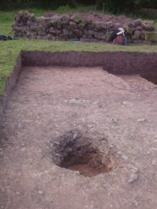 ated that the site was forested before the earthworks were constructed. Three pieces of worked flint were found below the rampart and in the forest soil.
Trench 6 was an extension to Trench 2 along the top of the rampart to locate additional evidence for a stockade but no more postholes were found.
Ponthendre Trenches 3 and 5
These trenches were located in the crescent-shaped bailey to investigate any structures or activities there. Both trenches were quite sterile and neither found any indications that the bailey had ever been occupied. Only two pieces of late medieval or post-medieval pottery were found and these probably arrived during agricultural use of the bailey
Ponthendre Trench 4
This trench was on top of the mound where the southern horn of the bailey meets the moat around the motte. The purpose for this mound was thought to be either the base for a defensive tower at the end of the bailey palisade or the abutment for the bridge from the bailey up to the motte. No evidence was found for any structure having been built here. A number of burrows suggested that the mound may have seen later use as a rabbit warren.
Ponthendre Trench 7
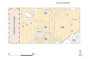
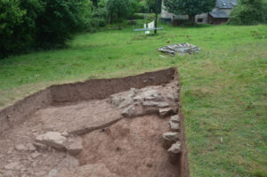 Trench 7 was cut across a depression at the east end of the bailey scarp. This was confirmed to be the entrance to the bailey. The end of the rampart was similar in construction to the section uncovered in Trench 2 with the addition of some larger stones. Other stones were randomly placed to provide some rough metalling across the entrance, either during the construction or during later agricultural use, but it was apparent that no proper access road had been constructed.
Ten sherds of pottery were recovered from this trench, with dates ranging from possible Roman to 17th century. Two pieces from below the rampart were Worcester cooking pot. Similar pottery is found at other early Marches motte and baileys.
Ponthendre conclusions
The trenches at Ponthendre sampled the top of the motte, the bailey, the rampart and the bailey entrance. It is very clear that no structures were built at any of these locations. Only a minimal amount of pottery was found, an insignificant amount of charcoal and no bone. This confirms that Ponthendre motte and bailey was not occupied and did not perform its intended function as a fortress.

