The Roman roads and their wider connections
[ The reader is advised to have a detailed OS map of the area to hand. A copy of the Cassini 1830-33 map would also be useful.]
The Roman military strategy of placing forts at one day’s march from the next certainly facilitated rapid troop reinforcement at trouble–spots. It did, however, depend on good communications and at the time that meant good roads. Construction methods varied according to terrain and resources available. While some roads, such as the Appian Way in Rome, were surfaced with paving stones and edged with corbels, those in Britannia were usually faced with impacted gravel, with or without edging stones. Roads could be straight for long stretches, but in difficult terrain, bends and twists were not unusual. Roads could also vary in width considerably. Standard features tended to include a raised central ‘agger’, made from the material dug from drainage ditches on either side of the road. To this raised mound a substrate of larger stones was added before ‘metalling’ the surface with impacted gravel. This created a strong, impervious road capable of resisting, at least for a time, the wear and tear of weather, army boots, horses and wheeled vehicles. Whenever necessary, repairs could be made by adding further substrate and gravel.
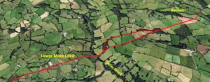
The Roman road connecting Abergavenny and Longtown is not at present clear. It may have followed the route of the modern Hereford road as far as Pandy, turning left along the Monnow to Clodock and hence Longtown – a distance of 15 miles. The road shows evidence of having long straight sections, which may have been rerouted in places due to such things as river incursions.
To the north of Longtown, there are a number of old trackways which could be contenders for a Roman road between Longtown 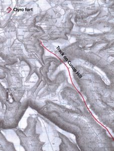 fort and the legionary fortress at Clyro. The Cassini OS map of 1830-33 shows some remarkably straight roadways which avoid the low ground of the Monnow Valley and run north along the ridge to its east. One of these, no longer in use except by farm vehicles, can still be found above the ruins of Craswall Priory and can be followed for a considerable way. Whilst we cannot be sure of the precise route of a Roman road between the two forts, there are sufficient grounds for further investigation (see ‘further considerations’ sections below).
To the north–east of Longtown the next place of note would have been Credenhill fort, taken over by the Romans and possibly used as a supply base during the early campaign. This would be superceded by the town of Magnis later in the first century, but whether Longtown fort was still occupied by this time is open to question. Between Credenhill/Magnis and Longtown the Roman road is obvious for much of the route. After crossing the Wye close to the modern Weir Garden, the road, referred to as Stone Street in the OS maps, tracks south west in a straight line to Brampton Hill before meeting the modern B4347 close to Bacton village. Stone Street bears all the 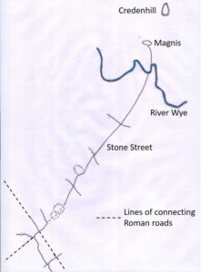 hallmarks of a Roman road, despite its having been modernised over much of its length; its straightness, relatively constant width, the fact that it follows both parish and field boundaries, even where the road itself is not obvious, all testify to both great antiquity and Roman engineering.
On close inspection, most of these features also become apparent over the next section of the road heading towards Longtown. While the B4347 takes a sharp turn south towards Abbey Dore and the Bacton road a sharp turn north, the line of the Roman road should continue west, but there is no obvious sign of it. Perhaps this is one of the reasons some have doubted the existence of the Longtown section of the road.
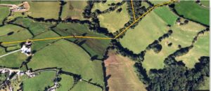
What is clear, however, from satellite images is that the line of the road continues as a boundary of two fields some 500m to the west before crossing a patch of rough ground and entering a small wood.
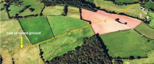
Field inspection of this patch of rough ground revealed some features which could indicate the remains of a raised roadway. Nothing was apparent within the wood, but the road appears to split at this point (see explanation below). The southern section is a tree-lined field boundary passing Holling Grange Farm and continuing to the Tremorithic (Tremorddig) road. This proved to be a raised, grassy trackway, some 5m wide and as much as 1m high in places.
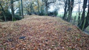
Significantly, this trackway is also a parish boundary and continues the straight line of our putative Roman road. This is the highest point of the roadway at 300m.
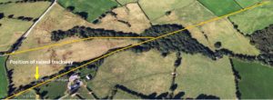
Continuing west beyond the Tremorithic road, the track is indistinct at first, but becomes a raised bank between two gullies, one to the south containing a small stream, the other a ditch.
The track here drops steeply to the Dulas Brook, currently crossed by a footbridge, and disappears in the field on the other side of the stream.
However, the Cassini OS map of 1830-1833 shows that a road crossed the stream at this point only 200 years ago, rising to the west to meet the long straight road across Lower Maescoed common, traditionally held to be Roman in origin.
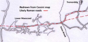
Returning briefly to the east side of the Dulas Brook, the Cassini map also shows the old road diverging to the north away from the track before turning east again and running parallel to it. This divergence is clearly seen on the ground as a raised bank with ditches on either side, continuing uphill to meet the Tremorithic road opposite the current entrance to Upper House Farm. In the 1830s this farm road continued on to Bacton village. It seems likely that this alternative route uphill from the Dulas Brook was established to provide an easier angled ascent for horses and wagons, but whether it dates back to Roman times is open to question. It is certainly true that dual-carriageway roads over difficult terrain were not uncommon in Roman times.
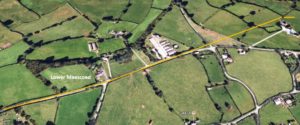
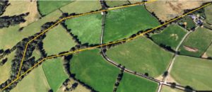
Continuing west from Lower Maescoed, the line of the Roman road diverges slightly from the modern road, which loops to the south before meeting the St. Margaret’s road. The Roman road probably ran along the north edge of what is now a small area of heathland, continuing along field boundaries on the other side of the St. Margaret’s road to meet the Michaelchurch road opposite the lane to Llanwonog Farm.
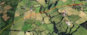
These field boundaries form a remarkably straight alignment with this top section of Llanwonog Lane. Closer to Llanwonog Farm, the track descends steeply through a 5m deep sunken lane into the Monnow valley. Here, the lane is narrow and rocky at its base, having been washed out by winter rainwater over the centuries. At the bottom of the hill, the sunken lane joins the metalled farm road, which crosses the Monnow and ascends through another sunken lane to Longtown castle. The modern road takes a dog-leg bend in front of the Baptist Church, but continuing the alignment of the ascending lane would take it into the centre of the northern bailey, perhaps adding support to the idea that this bailey was originally an annexe to the Roman fort. If so, a gateway between the annexe and the fort must have existed on the northern side, opposite the southern entrance coming in from Abergavenny. Without evidence, however, this northern annexe remains highly speculative. Other routes up to the fort from the bottom of Llanwonog Lane are possible. The Roman road may have followed the modern hedge boundaries south of Llanwonog Lane, entering the fort in the middle of the eastern rampart. The field boundaries, however, form the only evidence, as there is now no sign of an old track–way.
Taking all the evidence together – the field and parish boundaries, the remarkably straight alignment of the whole route and the numerous surface features still visible – it seems clear that we have been following the line of the Stone Street extension to Longtown fort, first mentioned in 1822 in ‘The Gentleman’s Magazine’, but sadly giving no details as to the route. The deviation from the road east of the Dulas Brook, at the highest point on the road, may also be Roman in origin, separating slow-moving up-hill traffic from that moving down-hill.
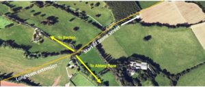
Given the first century date of Longtown fort, it seems likely that this route would have been the main artery between Magnis and Abergavenny at that time and an important part of the longer Watling Street West extension from Wroxeter to Carmarthen, described as Journey 12 in the later Antonine Itinerary. With Longtown fort probably falling out of use in the later first or early second centuries, an alternative route via Pontrilas and Abbey Dore, postulated by Margery and others, may have been constructed later to avoid the higher ground. This would have been the only advantage, as the distances between Magnis and Abergavenny are the same for both routes – 22 miles. However, no trace of this second road has yet been found, except at Abbey Dore, although this may be part of a different route to Castlefield fort (see below). Assuming this second road was built, the Bacton-Longtown road, despite the loss of the fort, would still have continued in use for centuries afterwards, with some stretches obviously surviving to the present day.
Other Roman Roads in the Area
In 1908, the Hereford Times reported in its Illustrated Supplement that a section of Roman road had been uncovered at Abbey Dore railway station. Some Roman artefacts were also recovered, including some nails and a fragment of horseshoe. The surface of the road was 13 feet wide, cobbled but with no edging stones, and bore parallel deep ruts 4 feet 6 inches apart, worn by the repeated passage of wagons. These ruts lay to one side of the road, leaving a space of 5 feet for pedestrians and passing vehicles. The cobbles may have been covered at the time with a surface of impacted gravel.
Since this early discovery, further stretches of the road have been investigated over the years, between Abbey Dore and Peterchurch, all showing the same features – including the wheel ruts* That this is an ancient road, probably of Roman construction, but possibly even older, is undoubtedly true. Further artefacts have also been found, including a Roman-date horseshoe, etc. The road, now a walking track in places crosses Stone Street east of Bacton and runs north-west through Vowchurch, Peterchurch, Dorstone and, significantly, points directly towards the location of the Roman forts at Clifford.
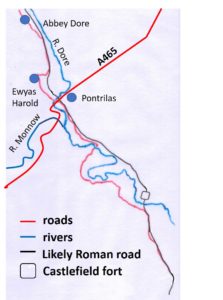 South from the Stone Street crossing, the line of the road follows the disused railway-line in places, but also links with the modern B4347 to Abbey Dore and on to Ewyas Harold, where it skirts around Callow Hill Wood, crossing the A465 to join the B4347 to Kentchurch. This road may have been the important link between Clifford (and later Clyro) and the fort at Castlefield on the River Monnow between Kentchurch and Garway. Today the B4347 takes a complicated detour via Grosmont, but in Roman times it may have taken a more direct route to Castlefield along the north side of the Monnow.
Did this road extend all the way to Monmouth? Today it is difficult to see a clear single routeway, with the river Monnow taking many twists and turns, through a complex landscape of low hills. South of Castlefield, however, after crossing the Monnow, the route may have followed the line of the relatively straight B4347 through a narrow valley to the village of Norton to the west of Skenfrith. From here a route to the west of the low hills lying to the south of Skenfrith could have again connected with the B4347 at a place called ‘The Boot’ on the Cassini map. From here, south-east along another straight, narrow valley, the road passed through Rockfield and on to Monmouth. Was this route the Roman road between Monmouth and Castlefield? Of course we cannot be certain, but it would seem to satisfy Roman engineering requirements for the shortest route over the easiest terrain. It is also interesting that the modern road bears the same number all the way from Monmouth to Abbey Dore, despite some obviously later detours.
What is also noticeable when inspecting the above Cassini route, is that another road, very straight in sections, branches off at ‘The Boot’ to pass north to the west of the Grosmont hills to meet the Abergavenny–Longtown road close to modern Pandy! Could this have been another Roman road connecting Abergavenny, Longtown, Castlefield and Monmouth by a different route?
*Thomas, M. ‘An Ancient Track in the Golden Valley’. Transactions of the Woolhope Naturalists’ Field Club, (1987) 186-92.
Longtown’s Roman Roads – further considerations.
Longtown Castle, built by the de Lacy family, was superimposed on a pre-existing earthwork rampart, more or less square in shape with rounded corners and surrounded by a wide ditch. The rampart sides are around 120 metres in length and stand up to 7 metres high. The excavations in 2017 produced evidence that the rampart was based on the turf embankment of a Roman fort. This was later re-used and strengthened, probably by the English army of Harold Godwinson that crossed the border into Wales in response to Gryffydd ap Llewelyn’s sacking of Hereford in 1055.
The shape and size of the rampart is typical of a Roman auxiliary fort, usually manned by a garrison of around 500 men. Although only a small area of Roman contexts has been excavated, no stonework or ceramic building materials were found, indicating that the fort was a timber construction that remained in use for a relatively short duration. Pottery and radiocarbon dating pointed to a first century occupation, possibly extending into the early second century. It was probably one of the network of Roman forts built during Publius Ostorius Scapula’s campaign against the Silurian tribe around 50AD.
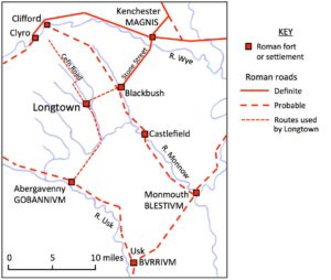
Roman roads in Herefordshire and Gwent
When the legions moved into hostile territory it was the normal practice to site forts no more than a day’s march apart. Longtown fills the gap between the first century forts at Clifford and Abergavenny (Gobannium) sited 13 miles north and 12 miles south of Longtown respectively. Five miles east-north-east of Longtown at Blackbush Farm in the Golden Valley there was another fort. Surface finds of Flavian pottery suggest that this fort is a little later than Longtown’s fort and, since it is so close, may have superseded it. The Blackbush fort is connected by a known Roman road, Stone Street, to the town of Magnis that supplanted the Iron Age fort and regional centre at Credenhill.
It is uncertain whether Longtown’s fort would have merited the provision of fully made up roads but even if this were not the case, it would have certainly needed adequately maintained trackways to facilitate movement of troops and supply wagons. The obvious place to start looking in the landscape for evidence of the roads is in the immediate vicinity of the fort. Roman forts were usually built to a standard pattern, having a rectangular or square palisaded embankment with gatehouses sited approximately midway along each of the four sides. At Longtown only the position of the southern gate is still visible, as the openings of the other three gates were apparently blocked by the medieval enhancement of the rampart. The present road through the village does not follow the line of the Roman roads running north-south from the fort. Instead its route is parallel to them, new cuttings through the rampart having probably been made by the Norman castle builders.
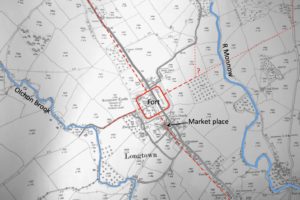
Probable Roman roads servicing the fort in Longtown, based on the 1904 OS map, which omits recent developments.
The first section of road emerging from the south gate is likely to have been destroyed when the moat of the Norman castle was dug and the medieval church was built. However, below the church, Longtown’s medieval market place is likely to have straddled the road and made use of it. The course of the road appears to follow a boundary line that extends around half a mile as far as the Crown Inn.
This boundary clearly has some antiquity. Several cottages were built on the narrow strip of land between the boundary and the medieval/modern road. Lord Dudley’s survey of Longtown in 1566 remarks on a number of houses with ‘no manner of ground belonging to them, but the very plot where the house stood’.
In 2001 an evaluation excavation at Greyhound Farm placed a trial trench across this boundary line. Beneath modern concrete ‘a disturbed layer of stone (35) formed an earlier surface, which overlay a dark humic stony soil (18). Layer 18 overlay a V-profiled ditch (24), which curved north to south through the north-eastern end of the trench.’ It is possible that the layer of stone and the accompanying ditch are the remains of the Roman road from the fort, although they were not recognised as such at the time.
After the Crown Inn the course of any road heading south is restricted by the terrain. With the rapidly rising slope of Hatterall Hill on one side and the floodplain of the River Monnow on the other, the Roman road must have generally followed the line of the modern road.
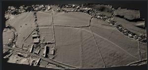
The accurate digital terrain model below shows a curved linear feature just north of Clodock, previously identified from LiDAR as a possible stretch of Roman road. However, probing with an iron bar found that this feature has no stone foundation or metalling. It is likely to be just an ancient riverbank forming a boundary between ploughland and meadow. Similar natural features can be seen elsewhere along the river.
There are a number of straight sections on the road down to Pandy that could overlay the Roman road. After Pandy the Old Hereford Road, rather than the A465, is may well follow the route taken by the Roman road on to the Roman fort and settlement of Gobannium at present day Abergavenny.
Returning to Longtown fort, a straight section of farm track runs perpendicularly from below the midpoint of the western side of the rampart down to the Olchon Brook and then continues on the other side as a footpath heading in the direction of Hatteral Hill. It is reasonable to presume that this marks the route used by the garrison to access the brook, which would have provided a reliable source of clean water. Tracks continuing to the ridge of the hill would have allowed patrols to observe activity in the adjoining valley.
Any remaining trace of the road leaving the north gate is now completely obscured by the building of the new school and a recent housing estate, incidentally given the name Roman Way. However, maps from before these developments show a boundary line running northwards from the midpoint of the rampart, continuing the line of the boundary south of the fort. After a quarter of a mile the projection of the boundary joins the existing road heading towards Hay-on–Wye. This road runs for three miles in a direct line along the west side of the River Monnow to Craswall. Here a track fords the river and continues to the ridge of Cefn Hill. An ancient trackway, the Cefn Road, runs for several miles along the ridge of the hill, heading in the direction of the legionary forts at Clifford and Clyro in the Wye Valley.
The road from the east gate is probably indicated by two hedge lines crossing the manorial demesne closes, known as the Lord’s Land. The hedges are offset from each other, indicating that they were once on different sides of a trackway that headed from the fort towards the River Monnow. It is not obvious where this route crossed the river. It may have turned northwards to join the track to Llanwonnog Farm, identified by the Ordnance Survey in the last century as a Roman road. This would have given a somewhat tortuous approach to the fort, so alternatively the road may have continued in a straight line to the river before turning north. In either case the road from the east gate would have linked up with the Roman road passing through Lower Maescoed and on to Magnis via Stone Street.